


| ||
|
|
|
|
|
|
|
Local History |  |
The area around Freshwater Bay has always been a popular place for settlement. It has a lot going for it, high well drained Downs with good defensive views, abundant freshwater ( hence the name),and wooded valleys with abundant fruits and wildlife. A northern and southern coastline with fish, shellfish and sea birds. The safety of being on an island, yet not far from the mainland. The result is that there is a lot of history to the Isle of Wight. |
|
 |
The earliest recorded inhabitants of the Island, though it was not an island
then, are the dinosaurs. The Island is such a popular place for the discovery
of fossils that it has been given the title of Dinosaur Isle. To make the most of that title there is a museum with a good interactive exibition of local remains in Sandown. There is also a fossil collection at Blackgang which is a little closer to Freshwater. | ||
 |
Next we have the Romans and they settled all over the Island, including around Freshwater, from AD43 to AD 410. It is probably that at this time the Western end of the Island was in effect its own island with water flowing through from the present Bay to the western Yar river. The Bay itself would have been further out into the English Channel as coastal erosion has changed the shape dramatically over the years. Of the known villas the two main ones were located at Newport and Brading, however, the Yar did support a small port located just beyond the present barrier. During the Roman period the Island was called Vectis, a name still commonly found in house names and on the buses. After AD 410 the Island carried on in almost isolation. There were some useful minerals to exploit, especially iron and it was still very agriculturally based. The mainland, and probably the Island, were regularly subjected to invasion by Germanic peoples. Certainly the mainland kingdom of Wessex was attacked on a regular basis. Finally in AD 530 the Island fell to the combined Saxon and Jute armies. The Jutes ruled the Island from 530 to 686 and this period was famous because the Jutes were pagans. The Island was therefore probably one of the last places to take up the Christian faith again. It has been suggested that the names for Yarmouth and Wellow originate from the Jutes. It is also written that the mother of Alfred the Great was descended fromthe Jutish royal house of Wight. | ||
|
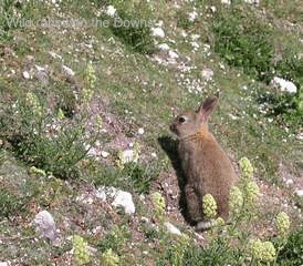
The west of the Island, being away from the main administrative unit at Carisbrooke, remained a quiet place until the advent of high import duties on products coming into Britain. A quick look along the coastline shows that this end of the Island was almost purpose made for smuggling. Every isolated church, pub and farm has some claim to fame in that quarter. Of course the locals had to have some legitimate employment and this took three main forms, fishing, crops and rabbits. Headon Warren is, as the name suggests, a centre for rabbits, not just then but now as well. Rabbits accounted for one third of the Island's income with their skins and flesh being valuable export items. A lot of people are convinced that they are getting their revenge though by undermining the cliff edges and encouraging coastal erosion. On an early morning walk, or as the sun goes down you will certainly see a lot of rabbits about. | ||
|
One of the most famous people to be associated with Freshwater was Robert Hooke. Famous but not famous, for he achieved a lot but was never given as much credit as he deserved. He was born in the rectory at Freshwater on the 18th July 1635, the son of the curate, John Hooke senior. Robert Hooke moved to London in 1648 and was educated at Westminster School and Christ Church, Oxford. He is credited with the invention of the watch spring, the development of microscopes and after the great fire of London, the design and lay out of many fine London buildings. He is remembered in the naming of Hooke Hill, a small memorial stone, and the Hooke trail, all found near the junction of Afton Road, School Green Road and Stroud Road. | |||
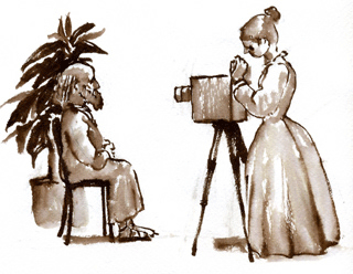 |
Probably the most famous resident of the area and one closely associated with Freshwater Bay, was Alfred, Lord Tennyson who moved into Farringford House, Bedbury Lane, in 1853. This prompted other famous people from the Victorian period to visit Freshwater, one being Julia Margaret Cameron the pioneering lady photographer. She created pictures that were based on Tennyson's poems and also recorded his many visitors. Copies of these are on show at Dimbola Lodge, her former home, just up from the Bay. | ||
|
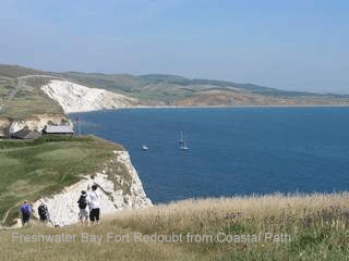
1855-56 saw the building of Fort Redoubt on the cliffs at the western end of the Bay. This was built in order to stop the French landing and attacking the other forts on the Solent side of the Island.It is not open to the public but the main layout can still be observed from above on the Downs. A deep, brick lined ditch was cut to the north and west in order tostop an attack from the land. Inside the ditch was a barrack block designed to house 24 soldiers. On the top of the newly created island was a parade ground and a one story flat roofed building. This was made into two stories in 1936 as quarters for the officers and NCOs. Extensive tunnels and rooms were built under the chalk of the cliff so as to be safe from mortars. | ||
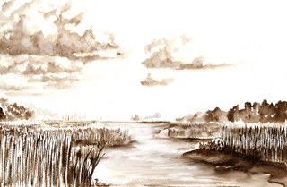 |
Afton Marsh which leads from behind the car park and down eventually to
the barrier and the western Yar is also well worth a look. Historically
it has also been through many changes. Originally barges were regularly brought up to a point almost opposite to the end of Coastguard Lane. These could then be loaded or unloaded so as to supply vessels at anchor in the Bay. When vessels increased in size and no longer used the Bay the area became grazing land and eventually, when the barrier was built, more solid ground. The plots along Afton Road were sold with some space on the current marsh. Owners in a few cases converted this bit of land into tennis courts but the dampness of the ground and the mosquitoes prevented full enjoyment. Eventually the area was allowed to become the marsh that it is now. This is protected as a bird nesting site and for botanical species. | ||
 | |||