


| ||
|
||
|
|
|
|
Local Walks from Freshwater Bay car park Lasting about 5 hours including stops for tea, pictures and rest breaks These are two of the most obvious extended walks, each going in the opposite direction up onto the Downs. That does mean that you need to start off fresh! The Classic walk. This will take you from Freshwater Bay, over Tennyson Down to the Needles, then back along the base of the Downs to St Agnes church and past Dimbola Lodge to the Bay. 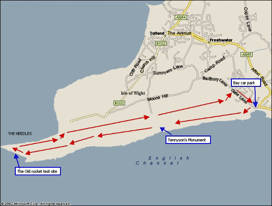 From the car park, turn right into Gate Lane. Follow the road until you come to the toilets and bus stop. Here, turn left into the road in front of the toilets. A short distance along there is a gate on the right into Easton Field. Go through the gate and start the long climb up the field to the gate at the top. Pass through the gate and you are up onto Tennyson Downs. The cliff edge is very dangerous and you will see cracks in the ground where the next slippage will take place, so keep control of dogs and children. Just proceed up the hill towards the monument. Stop every so often and look behind you. The views all around are just breath taking.
When you get to the monument, take a rest, admire the cross and examine the toposcope. The walk proper continues downhill and westwards. When you get to the end of the Downs, above the Needles, there are some old Coastguard cottages on the right with a radio mast behind them. Either bear right to join the road below the cottages or if you are sure footed, head for the radio mast and a stile over the fence on the Channel side. Go over this and follow the path down to above the rocket test site. It can be a bit tricky for the last few feet. You will find yourself on a large platform of concrete. There is a picture of how the site was used to test the engines of the British Blue Streak and Black Knight rockets. Beyond the picture is a path heading further westwards, go down this to get the best view of the Needles. You would be amazed how many people walk this far and never see the Needles properly because they did not go that extra few metres. Above you is the present Coastguard lookout. Follow the road up to this and just beyond you may find that the small ice cream shop is open within the old testing complex. Follow the path up and down by the side of the cliffs to the Needles Old Battery.(The Battery is National Trust property and there is a charge for admission, it also hosts a small cafe and the only toilets on the headland! ) The road then goes back along the inside edge of the cliffs above Alum Bay. Follow this until you come to the point where the road narrows and turns sharp left beside a couple of small houses. On the other side of the road is a footpath going along the lower part of the Downs. If you do not fancy the cafe at the Alum Bay complex, then a few hundred metres along this path is a cut down to the farm on the left which, in season, offers cream teas (reputedly the best on the Island!). Back on the path, follow this as it zig zags along the edge of the Downs until it rises up close to the site of the old beacon, moved here after the Tennyson Monument was erected in its place. Go over the stile and follow the track back down the hill. There are some lovely views of Hurst Narrows and Fort Albert from this track. This brings you down to the Highdown car park which is a disused quarry. The road to the left takes you to the High Down Pub or, by going straight on, through a small path up the bank, you come to the grass area on a line with the monument. Go across the grass to another gate and through this to the path along the base of the trees that cover the northern side of the Tennyson Downs. Follow the path by keeping straight on. Eventually you will come out through a gate and onto the top of Easton Field. Go straight on a few metres and through the next gate. This takes you down a path that comes out beside the thatched church of St Agnes. Turn right down Gate Lane. You will pass Dimbola Lodge on the right and then ahead is the Bay. Walk 7. This one goes Eastwards from the Bay, up over Afton Down to Five Barrow Down. Then down through Brook to Brook Chine and back along the Coastal Path to Freshwater. One thing I would say is that the last bit from Compton Bay goes up alongside the Military Road and unless used to long walks this can be a killer! 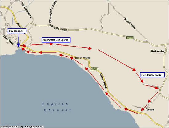 From the car park turn left and cross Afton Road. Proceed up the Military Road until you reach the Plot on the left, just beyond the houses. Turn left into Southdown Road and then right and follow the signs for the Freshwater Golf Course. The original golf course was sited on Tennyson Down, towards Alum Bay but was moved here, so you have the strange situation of a gold course with public rights of way through it. There are small subtle signs requesting that you keep to the pathways but the golfers know that they must expect walkers and the only inconvenience can sometimes be a request that you stop for a few minutes in order that they can take a shot. The golf course extends a long way along the ridge, right up to a line with Compton Bay, but you will know when you reach the end as there is a fence and gate. You now enter a more natural world and the track takes you along just below the ridge of the Down. There are fantastic views across the English Channel to be had from here. Eventually you come to Five Barrow Down, just above Brook and ahead you can see Brook House and the church below it. Drop down the track and through the gate at the end. Follow the lane to the road. Keep in to the edge of the road and turn right towards Brook. After passing the church take the right hand road through the village and down to the Military Road.
Go slightly
right and then cross the road to the car park at Brook Chine. From the car park
follow the signs for the Coastal path along the cliff top heading towards Freshwater Bay. I would advise staying close to the road until the grass above the cliffs becomes quite wide. When safe tracks appear on the left, through the grass, follow these down past a small monument to a child that fell over the cliff. The path goes in front of some houses and another small monument to a WW2 pilot, and down to the end of the Bay. Here there are some steps going down onto the promenade. Follow this past the Lifeboat station. The car park is on the right, across the road. See the Picture Gallery for sample views. The pictures in the gallery have been reduced in quality in order to speed up the site but we hope that they give some sort of idea of the views that you will see on these walks. | ||

| ||